TEMPEST-D Mission

To demonstrate that such a train of 6U CubeSats has the capability to contribute to NASA Earth science goals, the TEMPEST Technology Demonstration (TEMPEST-D) mission is in progress. TEMPEST-D is a partnership among Colorado State University (Lead Institution and validation), NASA/Caltech Jet Propulsion Laboratory (instrument and calibration) and Blue Canyon Technologies (spacecraft and mission operations). The TEMPEST-D satellite was launched on May 21, 2018 on Orbital ATK’s ninth commercial resupply mission to the International Space Station and successfully deployed into orbit from the ISS by NanoRacks on July 13, 2018, from an initial orbit with 400-km altitude and 51.6° inclination to demonstrate that TEMPEST-D radiometer calibration can meet the needs of the TEMPEST investigation. TEMPEST-D has met all mission requirements on schedule and within budget.

After achieving first light on September 5, 2018, the TEMPEST-D mission has successfully achieved TRL 9 for both the instrument and spacecraft systems. TEMPEST-D performed its first full-swath orbital observations capturing Hurricanes Florence and Helene over the Atlantic Ocean on September 11, 2018, revealing the eyes of the tropical cyclones surrounded by towering, intense rain bands using a millimeter-wave radiometer on a CubeSat.

TEMPEST-D brightness temperatures have been compared with those of four on-orbit reference sensors observing at similar frequencies, including the NASA/JAXA Global Precipitation Mission Microwave Imager (GMI) and the Microwave Humidity Sounders (MHS) on NOAA and EUMETSAT operational meteorological satellites. Cross-calibration results based on 50 days of data over a 13-month period demonstrate TEMPEST-D absolute calibration accuracy within 1 K of reference sensors, as well as TEMPEST-D calibration precision within 0.7 K of reference sensors, well within the mission requirements. This level of agreement indicates that TEMPEST-D is a very well-calibrated and stable radiometer with very low noise, rivaling that of much larger and more expensive operational instruments. After more than 20 months since first light, TEMPEST-D continues to produce global science data from low Earth orbit.

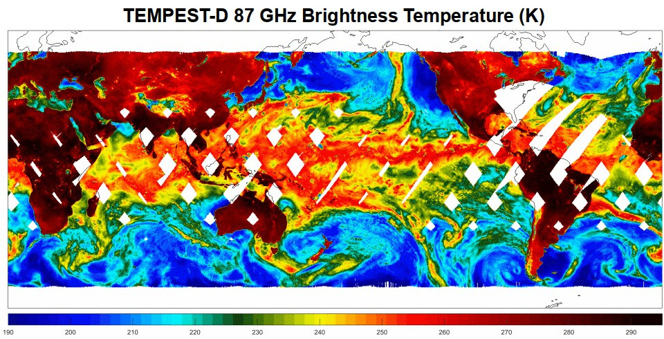
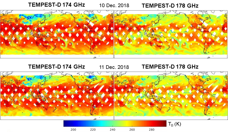
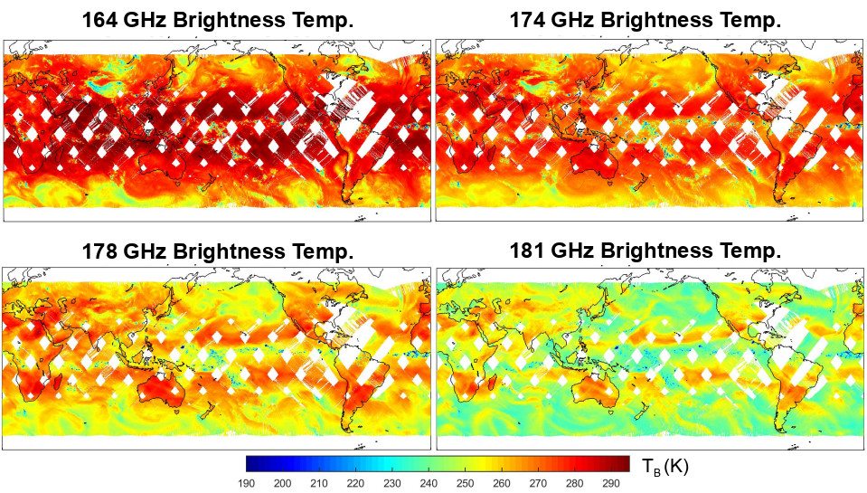
Animation of global brightness temperature measurements (K) at 87 GHz performed by TEMPEST-D on 8-12 December 2018. Calibrated brightness temperatures are shown, but fine geolocation correction has not yet been applied.

(Click to see animations at all five TEMPEST-D frequencies.)

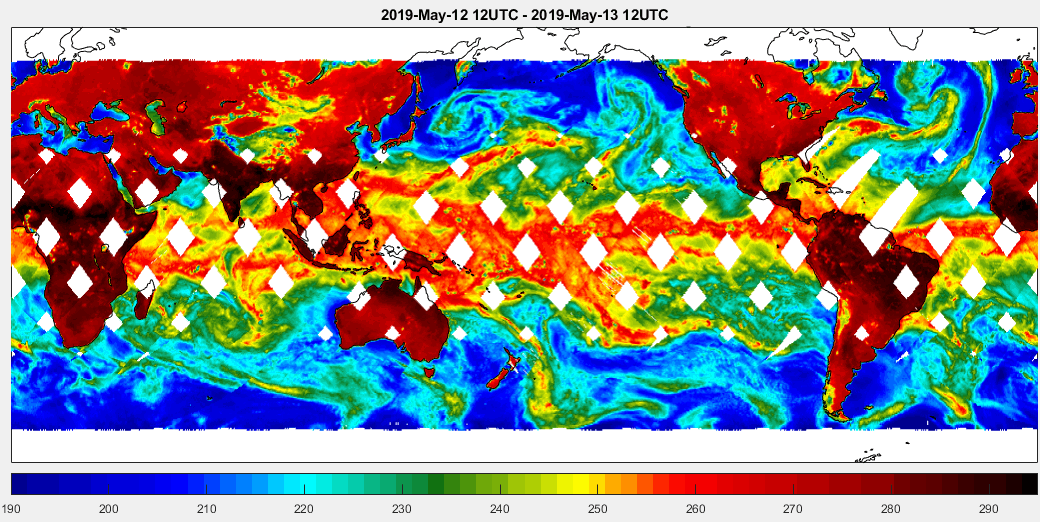
Animation of measured global brightness temperature measurements (K) at 87 GHz performed by TEMPEST-D on 12-19 May 2019. Calibrated brightness temperatures are shown, but fine geolocation correction has not yet been applied.
Global brightness temperature measurements (K) at 87 GHz performed by TEMPEST-D on 11 November 2019. The 87-GHz channel is primarily sensitive to water vapor and is also the most sensitive to the surface emission among the five millimeter-wave frequencies measured by the TEMPEST-D instrument in low Earth orbit.
Global brightness temperature measurements (K) at 164, 174, 178 and 181 GHz performed by TEMPEST-D on 11 November 2019. These sounding channels near 183 GHz are sensitive to water vapor at increasing altitudes in the troposphere. A band of convection in the inter-tropical convergence zone (ITCZ) is clearly evident near the equator.
NEW: Results of cross-calibration of TEMPEST-D brightness temperature observations with those of four on-orbit reference sensors, including the NASA/JAXA Global Precipitation Mission Microwave Imager (GMI) and the Microwave Humidity Sounders (MHS) on NOAA and EUMETSAT operational meteorological satellites.
(Click image to view complete presentation.)

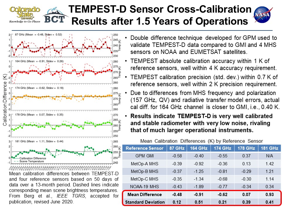
NEW: Reising et al., "Calibration and Validation of TEMPEST-D Microwave Atmospheric Sounder on a CubeSat for Applications in Weather Prediction and Climate Monitoring," European Geophysical Union General Assembly 2020 (Virtual Meeting), May 5, 2020.
Global brightness temperature measurements (K) at 174 and 178 GHz performed by TEMPEST-D on 10-11 December 2018. These sounding channels near 183 GHz are sensitive to water vapor at increasing altitudes in the troposphere. A band of convection in the inter-tropical convergence zone (ITCZ) is clearly evident near the equator.
Global brightness temperature measurements (K) at 164, 174, 178 and 181 GHz performed by TEMPEST-D on 14 May 2019. These sounding channels near 183 GHz are sensitive to water vapor at increasing altitudes in the troposphere. A band of convection in the inter-tropical convergence zone (ITCZ) is clearly evident near the equator.
This animation combines the TEMPEST-D data with a visual image of the storm from NOAA's GOES weather satellite.

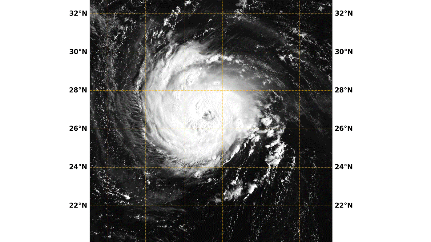
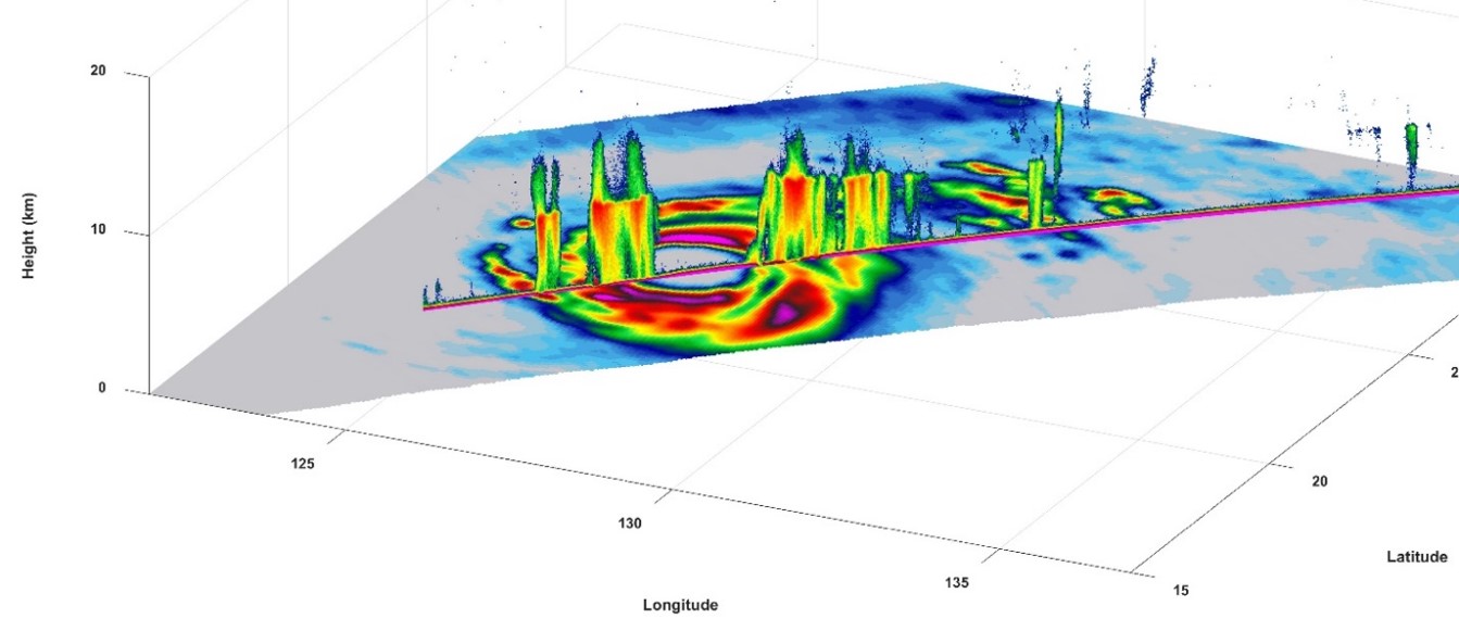
This animation combines the TEMPEST-D (Temporal Experiment for Storms and Tropical Systems Demonstration) data with a visual image of the storm from NOAA's GOES (Geoweather Operational Environmental Satellite) weather satellite. The brightly colored image taken by TEMPEST-D captures Hurricane Florence over the Atlantic Ocean. The colors reveal the eye of the storm, surrounded by heavy rain. The green areas highlight the extent of the rain being produced by the storm, with the most intense rain shown in the yellow and red areas. In contrast, the greyscale shows the visible image of Florence taken by the GOES weather satellite, which shows the familiar cyclone-shaped clouds of the storm, but doesn't reveal what's inside.

Image Credit: NASA/NOAA/Naval Research Laboratory Monterey/JPL-Caltech

TEMPEST-D captures intense precipitation in tropical cyclones on a global basis from a small satellite. This image shows combined TEMPEST-D 165 GHz brightness temperature imagery (in the horizontal plane) and RainCube Ka-band radar reflectivity profile (in the vertical plane) across Typhoon Trami on 28 Sept. 2018.
Global brightness temperature measurements (K) at 87 GHz performed by TEMPEST-D from 400-km orbit on 15-16 October 2018. The 89-GHz channel is primarily sensitive to water vapor and correlates well with satellite-derived total precipitable water (TPW) products.
Global brightness temperature measurements (K) at 164-181 GHz performed by TEMPEST-D on 15-16 October 2018. These sounding channels are sensitive to water vapor at increasing altitudes in the atmosphere up to 10 km. A band of convection in the inter-tropical convergence zone (ITCZ) is clearly evident near the equator.